
Description
📘 Chapter Three: Major Features of the Earth’s Surface – Form 1 Study Guide
Discover the Land, Water, and Landforms That Shape Our Planet
🌍 What Is This Chapter About?
This chapter explores the physical features that make up the earth’s surface — the continents and oceans, the major relief features found on land, and the various water bodies that cover our planet. Understanding these features is fundamental to comprehending the physical environment we live in.
✅ What You’ll Learn Inside
🔹 The Earth’s Surface
Composition – Land (29%) and water bodies (71%, the hydrosphere)
Interaction of Land and Water – How coastal features are formed:
Gulf – Ocean penetrating into land (e.g., Persian Gulf, Gulf of Guinea)
Strait – Narrow water passage separating two landmasses (e.g., Strait of Gibraltar)
Cape – Land projecting into the sea (e.g., Cape of Good Hope, Cape Horn)
Peninsula – Land almost surrounded by water (e.g., Msasani Peninsula, Arabian Peninsula)
Isthmus – Narrow land joining two larger landmasses (e.g., Isthmus of Panama, Isthmus of Suez)
🔹 The Seven Continents
Asia – Largest continent (44.6 million km²), bordered by the Arctic, Pacific, and Indian Oceans
Africa – Second-largest (30.3 million km²), the only continent crossed by both the Tropic of Cancer and the Tropic of Capricorn
North America – Third-largest (24.7 million km²), connected to South America via the Isthmus of Panama
South America – Fourth-largest (17.8 million km²), bordered by the Atlantic and Pacific Oceans
Antarctica – Fifth-largest (14 million km²), uninhabited due to extreme cold
Europe – Sixth-largest (10.1 million km²), separated from Asia by the Ural Mountains
Australia – Smallest continent (8.5 million km²), includes New Zealand
🔹 Major Relief Features
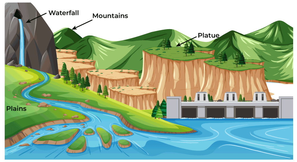
Plains – Flat, continuous stretches of land (e.g., Serengeti Plains, Indo-Gangetic Plains)
Plateaus – High-altitude flat-topped areas:
Tectonic Plateaus (e.g., South African Plateau)
Lava Plateaus (e.g., Deccan Plateau, India)
Intermontane Plateaus (e.g., Tibetan Plateau)
Mountains – Four main types:
Fold Mountains – Formed by compressional forces (e.g., Himalayas, Andes, Alps)
Block Mountains – Formed by faulting (e.g., Uluguru, Usambara, Ruwenzori)
Volcanic Mountains – Formed by lava cooling:
Active: Oldonyo Lengai (Tanzania), Vesuvius (Italy)
Dormant: Mount Kilimanjaro (Tanzania), Mount Fuji (Japan)
Extinct: Mount Rungwe (Tanzania), Mount Kulal (Kenya)
Residual Mountains – Formed by weathering and erosion (e.g., Sekenke Hills, Tanzania)
Rift Valleys (Grabens) – Long, narrow depressions between parallel faults:
The Great African Rift Valley – Longest in the world, stretching from Jordan to Mozambique
Eastern Arm: Lakes Turkana, Magadi, Eyasi, Natron, Manyara
Western Arm: Lakes Nyasa, Rukwa, Tanganyika, Kivu, Albert, Edward
Basins – Bowl-shaped depressions (e.g., Lake Victoria Basin, Congo Basin)
🔹 Water Bodies
Rivers – Fresh water flowing in a definite channel:
Tanzania: Rufiji, Ruvuma, Kagera, Pangani, Malagarasi, Ruaha, Wami, Ruvu
Africa: Nile (6,650 km, longest in the world), Congo (4,700 km)
Lakes – Depressions containing fresh or salty water:
Tanzania: Victoria, Tanganyika, Nyasa, Rukwa, Manyara, Eyasi
World Records: Caspian Sea (largest lake), Lake Superior (largest freshwater), Lake Baikal (deepest)
Seas – Large bodies of salty water partly surrounded by land (e.g., Red Sea, Mediterranean Sea)
Oceans – Five major oceans by size:
Pacific Ocean (largest and deepest)
Atlantic Ocean
Indian Ocean (borders Tanzania)
Southern Ocean
Arctic Ocean (smallest and shallowest)
🔹 Features of the Ocean Floor
Continental Shelf – Shallow, rich in marine life, major fishing ground
Continental Slope – Steep slope connecting shelf to deep ocean floor
Mid-Ocean Ridge – Raised part of the ocean floor (e.g., Mid-Atlantic Ridge)
Deep Sea Plain (Abyssal Plain) – Flat, undulating deep ocean floor
Abyssal Hill – Small, sharp hills rising from the abyssal plain
Ocean Deep/Trench – Deep, narrow depression (e.g., Mariana Trench, 10,994 m)
Islands – Continental, Oceanic, and Coral islands
🎯 Key Features
10 Clear Summary Points for quick revision
5 Short-Answer Questions to test understanding
10 Structured Questions for deeper analysis
5 Essay Questions for critical thinking and exam preparation
Real Tanzanian Examples throughout — Mount Kilimanjaro, Oldonyo Lengai, Uluguru Mountains, Lake Victoria, Lake Tanganyika, Rufiji River, Mbozi meteorite, and more
Diagrams and Classification Tables for easy comprehension
👨🎓 Who Is This For?
Form 1 Students beginning their secondary geography course
Teachers looking for a well-structured, ready-to-use teaching resource
Parents supporting their children’s learning at home
Anyone preparing for national examinations (NECTA)
💡 Why Choose This Guide?
✔ Aligned with the Tanzanian secondary school syllabus
✔ Written in clear, simple English for easy comprehension
✔ Packed with local examples students can relate to
✔ Includes practice questions with varying difficulty levels
✔ Perfect for classroom teaching, self-study, and revision
✔ Covers cross-topic connections (links to Chapters 1 and 2)
📥 Get Your Copy Today!
Whether you’re a student aiming for top marks, a teacher preparing engaging lessons, or a parent investing in your child’s academic success — Chapter Three: Major Features of the Earth’s Surface is your essential companion for mastering the physical environment of our planet.
Start exploring the land, water, and landforms of our world today!
📚 Also Available:
Chapter One: The Concept of Geography
Chapter Two: The Solar System
The perfect companions to build a strong foundation in geography.
MITIHANI POPOTE — Quality educational resources wherever you are




Reviews
There are no reviews yet.